Water highlights


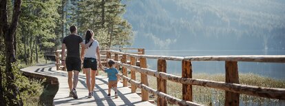
The Biotope trail in Rasen starts at the fire station in Oberrasen and is an ideal hike for families. The path leads through a beautiful natural biotope that is home to a rich variety of flora and fauna. The hike takes about 1.5 hours and offers a relaxed way to explore the diverse wildlife and plant life of the region. The trail is well-marked, easy to walk, and without significant elevation changes, making it perfect for children and older adults. Along the way, informative signs provide insights into the importance of the biotope and its inhabitants. This is an outing that pleasantly combines nature experience with education.
Coming from Innsbruck/Brenner (A): Drive on the Highway of Brenner (A22) until the exit Brixen/Pustertal, then go on along the SS49-E66 for about 50kms until you arrive in Olang/Valdaora.
Coming from Lienz (A): You can reach us also padding by Lienz in Westtyrol (A). You have to cross the Austrian-Italian border between Ahrnbach and Winnebach (B100-E66) and drive on the SS46-E66 until Olang/Valdaora
Coming from Bozen: Highway of Brenner (A22) until the exit Brixen/Pustertal, then go on along the SS49-E66 for about 50kms until you arrive in Olang/Valdaora.